

The Caminho da Mata Atlântica (CMA) [Atlantic Forest Trail] is a long-distance trail that crosses the states of Rio de Janeiro, São Paulo, Paraná, Santa Catarina and Rio Grande do Sul. Spanning approximately 4,000 km, it is divided into fifteen voluntary planning and coordination hubs, five of which are located in the state of Rio de Janeiro.
The municipality of Rio Claro (RJ) and its districts occupy a strategic position along the trail, establishing itself as a hub for connection and sustainable tourism. The region links conservation areas between the Serra do Mar and the Vale do Café, serving as a natural corridor that connects mountain landscapes and protected areas.
Upon completing the Núcleo do Café or continuing along the Núcleo Costa Verde, hikers and cyclists encounter mountains, numerous waterfalls, ruins, historic tunnels and a wealth of history throughout the route. The municipality is also part of the Mata Atlântica Bike Route, the cycling tourism version of the trail, recognized in 2025 by Bikepacking as one of the best long-distance bicycle routes.
“Rio Claro sits at a central point between two well-structured hubs, and can serve as either a starting or ending point for different crossings along the Caminho da Mata Atlântica. It is a stretch that combines history and nature like few others in the state of Rio de Janeiro”, explains Chico Schnoor, one of the CMA coordinators.
Among the many routes available, we have listed those recommended by local volunteers.
Núcleo Vale do Café: finishing point in Rio Claro
For those coming from the Núcleo Vale do Café, the route covers approximately 226 km and passes through Petrópolis, Paty do Alferes, Miguel Pereira, Vassouras, Engenheiro Paulo de Frontin, Paracambi and Cacaria, in Piraí, before reaching the municipality of Rio Claro.
Access to Rio Claro is via the Serra do Matoso, a stretch defined by natural landscapes, trails and viewpoints. “There, it is possible to stay at Sítio Pousada Beija-Flor, which preserves remnants of an old farm, and make use of the facilities at Cláudio Cordeiro’s property, which include a restaurant, swimming pool and horseback riding”, recommends Gisele Ferreira, nature tourism guide and CMA hub coordinator between Cacaria (Piraí), Mangaratiba and Rio Claro.
The following day, the route continues to the Represa do Barro Branco, along roads that cross farms and offer lunch stops, such as the historic Fazenda Palmeiras, located on the Estrada do Sertão. The path continues through the Sertão da Boa Vista, passing by the upper section of the Cachoeira do Bálsamo, already within Rio Claro’s territory. “This is an important support point, with locals who open their homes to receive hikers after the climb up Serra do Matoso, which is quite demanding”, explains Gisele.
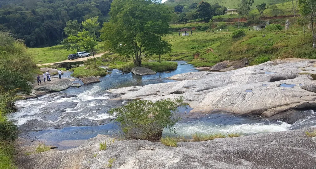
Cachoeira do Bálsamo – Photo: Gisele Ferreira
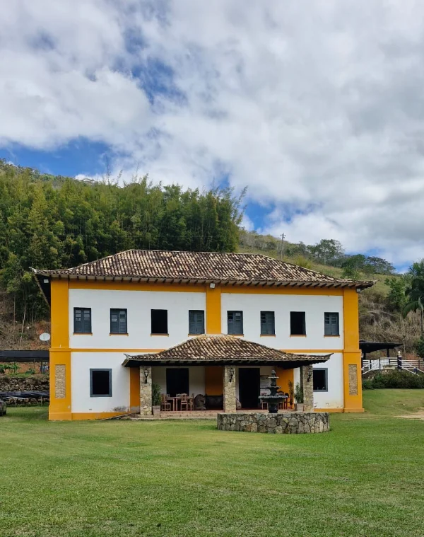
Fazenda Palmeiras
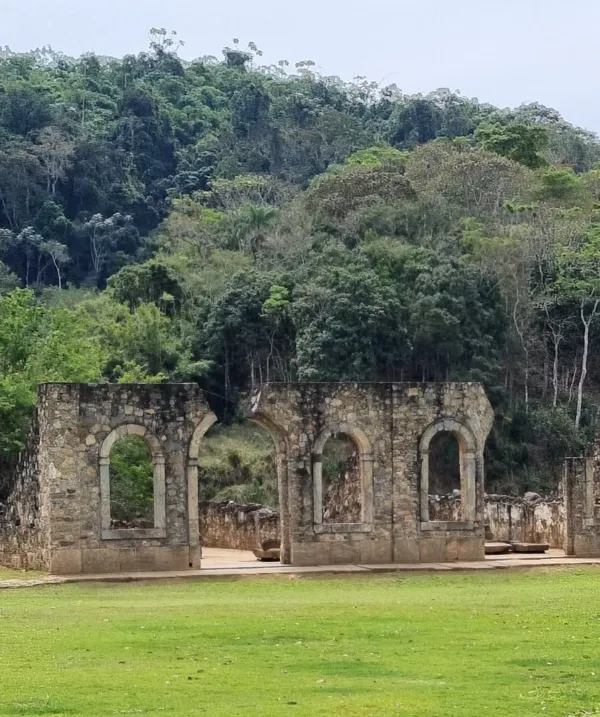
From the Cachoeira do Bálsamo, it is possible to continue along approximately 8 km of paved road to the Parque Arqueológico e Ambiental de São João Marcos, where historic ruins stand out amid the landscape. An alternative currently under development is to cover this stretch by boat across the reservoir, departing from Ponta da Caneta to the park, shortening the overall distance.
Julieta Santamaria, the first person to complete the entire Caminho da Mata Atlântica, passed through Serra do Matoso and entered Rio Claro via São João Marcos, continuing on to the park. “It is a historic place, home to one of the few open-air museums. The town was evacuated for the construction of the power plant and holds many stories from the era of slavery. It is a very interesting region for learning about Brazil’s past.”
From Parque São João Marcos, there are two options for continuing:
- Descending the Serra do Piloto, between Rio Claro and Mangaratiba, along a historic stretch that passes through a quilombo and waterfalls. From there, it is possible to head to Ilha Grande, explore the beaches and continue to Angra dos Reis, where the Travessia Angra–Lídice begins.
- For those who prefer not to head to the coast and wish to explore more of the region, there is the option of travelling to Lídice along a rural road, connecting with new stretches of the Caminho da Mata Atlântica.
Rural landscape on the route between São João Marcos and Lídice
For those departing from São João Marcos, a rural road of approximately 17 km connects the area to the centre of Lídice. The route crosses mountains and is better suited for cyclists, though still feasible — if more demanding — on foot. Julieta walked the road and came across a local resident who provided water and accompanied her for part of the way, riding his horse.
Maria de Lurdes Pena Campos, a Caminho da Mata Atlântica volunteer in Lídice who runs a campsite and cabin in the rural area, shares some of the region’s highlights:
“From my home, in the rural area, to the centre of Lídice, there are five waterfalls, many still little known and located on private properties: the Cachoeira do Sr. Antônio, do Suíço, on Ângelo’s land, on Patrícia’s farm, and the one belonging to Sebastião Marinho, the most visited in the region.”
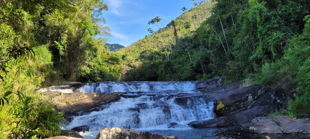
Cachoeira Sr. Antônio – Sertão Rio das Pedras – Photo: Maria de Lourdes
Those heading to Lídice to experience the Núcleo Costa Verde will travel largely along dirt roads. A good tip, according to Chico, is to visit the Cachoeira do Zé Claro, which offers a swim in the heart of the Mata Atlântica, with waterfalls and natural pools, as well as food and overnight facilities at the local campsite.
Lídice: starting point for the Núcleo Costa Verde
Lídice and its surroundings are home to a wealth of natural beauty. The municipality, which will host the V Jornada Cultural e Científica de Montanhismo in October 2026, marks the starting point of the Núcleo Costa Verde, conceived as a forest corridor connecting the Parque Estadual do Cunhambebe to the Reserva Biológica do Tinguá.
This is the second largest hub of the Caminho da Mata Atlântica, covering approximately 470 km. The route encompasses areas of preserved Mata Atlântica, including the buffer zone of the Parque Nacional da Serra da Bocaina and the historic Volta da Juatinga, in Paraty.
A must-stop for those travelling the Caminho is Pedra Chata, reached via a trail of approximately 8 km (round trip) with around 1,500 metres of elevation gain.
At the summit, the view opens up over the Costa Verde, with the sea stretching from Mangaratiba to Paraty, including Ilha Grande. Nearby, it is also possible to climb Pico do Papagaio, which offers views of Rio Claro’s mountains and a remarkable sunrise.
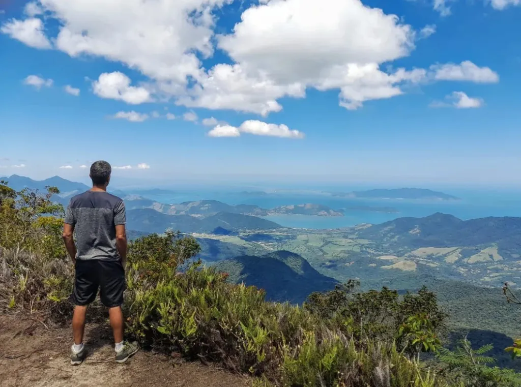
Cume da Pedra Chata – Photo: Maria de Lourdes
The Pedra Chata trail lies within the Parque Estadual do Cunhambebe, in Rio Claro (RJ), which encompasses areas of Mata Atlântica, particularly in the districts of Lídice and São João Marcos. The conservation unit connects to the Parque Nacional da Serra da Bocaina, and access to the mountain attractions is made easier by trails in the Lídice region.
Reginaldo Honorato, mountaineer and biodiversity coordinator of the Caminho da Mata Atlântica, highlights the diversity of vegetation along the Pedra Chata trail: “You start in a dense forest environment, with a waterfall. As you climb, the vegetation changes. Higher up, trees become sparse, and at the top, low-growing vegetation predominates. Every mountaineer should visit.”
Travessia Angra-Lídice
From Lídice, it is possible to begin the Travessia Angra–Lídice, a historic route considered one of the most beautiful in the state of Rio de Janeiro, marked by bridges and tunnels throughout the journey.
“It covers around 20 km. Along the way, you pass through 14 tunnels, following stretches of an old railway line. The path alternates between rural areas and the railway until reaching the coast”, says Maria de Lurdes.
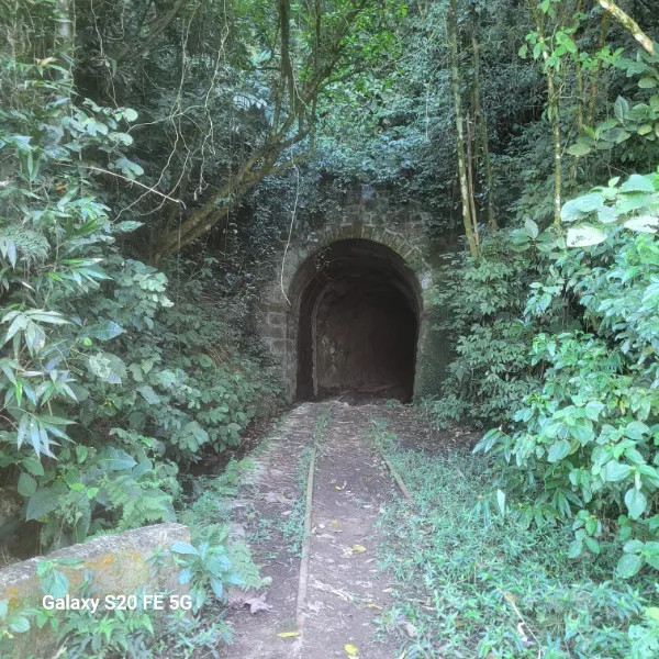
Tunnel on the Travessia Angra-Lídice. Photo: Maria de Lourdes
The route crosses preserved areas of Mata Atlântica, with forest stretches, rivers and small waterfalls along the way. Biodiversity is a highlight, with opportunities to spot birds, small mammals and a wide variety of native plant species. As the trail advances towards Angra dos Reis, the vegetation transforms and the climate becomes more humid. The transition between highlands and coast marks a crossing that unites history, nature and diverse landscapes.
Biodiversity: the region’s role in the ecological corridor
The regions of Rio Claro and Lídice contain important stretches of Mata Atlântica through which the Caminho passes, playing a strategic role in the connectivity of this biome.
The area acts as a link between large blocks of preserved forest. On one side is the Parque Estadual do Cunhambebe, connected to the Parque Nacional da Serra da Bocaina. On the other, the Reserva Biológica do Tinguá, forming an important ecological corridor. Rio Claro also lies along a stretch that crosses the Serra do Mar, a region essential for maintaining biodiversity.
“Connecting the Rio Claro and Lídice region is fundamental for wildlife, especially large mammals, as it facilitates species movement and contributes to the health of populations. That is why this area is so relevant as a biodiversity corridor”, explains Reginaldo Honorato.
Recently, in partnership with WWF, a camera trap monitoring project was carried out in the region, with survey points in Lídice, Barro Branco and São João Marcos. The data collected reinforces the importance of landscape connectivity for conservation and helps to better understand the dynamics of wildlife populations.
The region is home to a rich diversity of species, including felines such as the puma, the jaguarundi and the oncilla, as well as other mammals such as the crab-eating raccoon and the tayra, among many others.
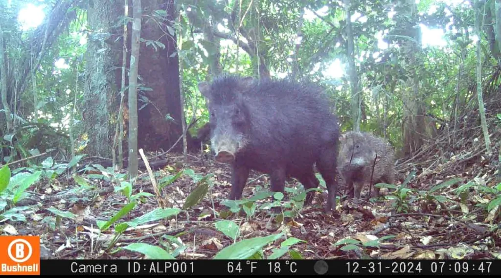
Image from the camera deployed by the Caminho da Mata Atlântica
The Caminho da Mata Atlântica website features an interactive map where you can explore these and other routes, as well as support points including food, accommodation, tourism partners and attractions, making trip planning straightforward.
This post is also available in: Português (Portuguese (Brazil)) Español (Spanish)